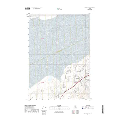
2021 Map of Anchorage B-7 NW
USGS Topo · Published 2021About this map
Birchwood Airport serves as a focal point for this coastal landscape where the Matanuska-Susitna Borough Anchorage Municipality boundary bisects the inlet. The residential patterns of Birchwood, Chugiak, and Peters Creek are defined by a network of local roads such as Birchwood Loop Road and Aurora Borealis Road, reflecting late-century suburban growth north of Anchorage. In the lowlands near the coast, several bodies of water including Beach Lake and Psalm Lake sit amidst the terrain, while Mink Cr drains toward the water. To the northeast, the land rises toward Coffee Point, and the southern reaches transition into higher elevations marked by the Ptarmigan Valley Trl. The map illustrates a contemporary Alaskan interface between aviation-dependent transport, municipal planning, and the natural drainage systems of the Knik Arm.
Find a feature on this map
65 named features on this map. Tap any name to fly to it.
Don’t see what you’re looking for? This feature index may not catch every label — zoom into the map to look around manually.
Map Details
Editions of this 2021 Anchorage B-7 NW Map
This is the sole edition of this map. No revisions or reprints were ever made.
Other maps of this area

1950 · Anchorage C-8
USGS Topo · 1:63,360

1950 · Anchorage C-7
USGS Topo · 1:63,360

1951 · Anchorage
USGS Topo · 1:250,000

1951 · Anchorage C-7
USGS Topo · 1:63,360

1952 · Anchorage C-7
USGS Topo · 1:63,360

1952 · Anchorage C-8
USGS Topo · 1:63,360

1952 · Anchorage B-8
USGS Topo · 1:63,360

1953 · Anchorage B-8
USGS Topo · 1:63,360

1960 · Anchorage B-7
USGS Topo · 1:63,360

1962 · Anchorage
USGS Topo · 1:250,000