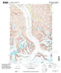
1993 Map of Anchorage C-2
USGS Topo · Published 2001About this map
Matanuska Glacier dominates the northern reaches of this Alaskan terrain, its massive icy tongue marked by intricate networks of crevasses as it flows through the valley. This 1993 edition, compiled from earlier mid-century topography, documents the glacial extent and surrounding high-altitude geography of the Matanuska-Susitna Borough. The southern half of the quadrangle is defined by a cluster of distinct summits named for Scandinavian nations, including Norway Peak, Finland Peak, Sweden Peak, and Denmark Peak. To the northwest, the prominent Mount Wickersham stands as a landmark above the glacier's path. The map provides a precise record of the ice fields and geological formations prior to the turn of the millennium, serving as a primary source for understanding the physical state of this remote region in the early 1990s.
Find a feature on this map
7 named features on this map. Tap any name to fly to it.
Don’t see what you’re looking for? This feature index may not catch every label — zoom into the map to look around manually.
Map Details
Editions of this 1993 Anchorage C-2 Map
This is the sole edition of this map. No revisions or reprints were ever made.
Other maps of this area

1948 · Anchorage D-3
USGS Topo · 1:63,360

1948 · Anchorage D-2
USGS Topo · 1:63,360

1948 · Anchorage D-1
USGS Topo · 1:63,360

1951 · Anchorage
USGS Topo · 1:250,000

1951 · Anchorage D-1
USGS Topo · 1:63,360

1952 · Anchorage D-2
USGS Topo · 1:63,360

1952 · Anchorage D-3
USGS Topo · 1:63,360

1960 · Anchorage C-2
USGS Topo · 1:63,360

1960 · Anchorage B-1
USGS Topo · 1:63,360

1960 · Anchorage C-3
USGS Topo · 1:63,360