
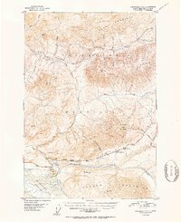
1952 Map of Anchorage D-2
USGS Topo · Published 1952About this map
Meekins Roadhouse stands as a primary waypoint along the Glenn Highway in this mid-century look at the high country between the Talkeetna Mountains and the Chugach Mountains. The landscape is dominated by the massive Matanuska Glacier and the braided channels of the Matanuska River, providing a clear view of the transportation corridor before extensive modernization. A solitary Airstrip and a network of paths like the Tractor Trail highlight the reliance on small aircraft and heavy machinery for navigating the interior. Distinctive landmarks such as Gunsight Mountain and Lion Head serve as natural beacons for travelers and geologists alike. This survey records the region's topography just after the post-war expansion of the Alaskan highway system, capturing the placement of essential roadhouses and remote mountain peaks such as Horn Mountain and VABM Guns 6441.
Find a feature on this map
30 named features on this map. Tap any name to fly to it.
Don’t see what you’re looking for? This feature index may not catch every label — zoom into the map to look around manually.
Map Details
Editions of this 1952 Anchorage D-2 Map
2 editions found
Other maps of this area

1948 · Anchorage D-3
USGS Topo · 1:63,360

1948 · Anchorage D-2
USGS Topo · 1:63,360

1948 · Anchorage D-1
USGS Topo · 1:63,360

1949 · Talkeetna Mountains A-1
USGS Topo · 1:63,360

1950 · Talkeetna Mountains
USGS Topo · 1:250,000

1951 · Anchorage
USGS Topo · 1:250,000

1951 · Anchorage D-1
USGS Topo · 1:63,360

1951 · Talkeetna Mountains A-2
USGS Topo · 1:63,360

1952 · Anchorage D-3
USGS Topo · 1:63,360
1952 · Talkeetna Mountains A-1
USGS Topo · 1:63,360