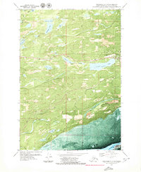
1979 Map of Anchorage C-7 SW
USGS Topo · Published 1980About this map
Wasilla stands as the primary hub in this late 1970s orthophotomosaic, where the corridor of The Alaska Railroad skirts the northern shore of Lucile Lake. The landscape is a complex network of glacial kettle lakes and drainage systems, including Meadow Lakes, Kalmbach Lake, and Beverly Lake. This era shows a community in transition, with local education centers like Iditarod Sch and transportation infrastructure such as the Airport and Jackfish Landing Strip supporting the growing Matanuska-Susitna population. Commercial activity is evidenced by several Gravel Pits along the rail line and roads like Church Road. To the south, the terrain descends toward the saltwater influence of the Palmer Slough, where Cottonwood Creek and Goose Bay Creek navigate the lowlands before meeting the inlet tide flats.
Find a feature on this map
34 named features on this map. Tap any name to fly to it.
Don’t see what you’re looking for? This feature index may not catch every label — zoom into the map to look around manually.
Map Details
Editions of this 1979 Anchorage C-7 SW Map
This is the sole edition of this map. No revisions or reprints were ever made.
Other maps of this area

1950 · Anchorage C-8
USGS Topo · 1:63,360

1950 · Anchorage C-7
USGS Topo · 1:63,360

1951 · Anchorage
USGS Topo · 1:250,000

1951 · Anchorage C-7
USGS Topo · 1:63,360

1952 · Anchorage C-7
USGS Topo · 1:63,360

1952 · Anchorage C-8
USGS Topo · 1:63,360

1952 · Anchorage B-8
USGS Topo · 1:63,360

1953 · Anchorage B-8
USGS Topo · 1:63,360

1960 · Anchorage B-7
USGS Topo · 1:63,360

1962 · Anchorage
USGS Topo · 1:250,000