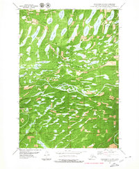
1979 Map of Anchorage C-8 SE
USGS Topo · Published 1980About this map
Meadow Lakes defines this landscape in the late 1970s, characterized by a dense concentration of glacial water bodies and developing infrastructure in the Matanuska-Susitna Borough. The corridor of The Alaska Railroad and Pittman Road provides the primary transit axis, supporting the small settlement of Pittman and several scattered gravel pits. The terrain is marked by an intricate network of waterways, including the winding course of Meadow Creek and Lucile Creek, which flow through a region dense with named lakes such as Bear Paw Lake, Prator Lake, and Visnaw Lake.
Find a feature on this map
35 named features on this map. Tap any name to fly to it.
Don’t see what you’re looking for? This feature index may not catch every label — zoom into the map to look around manually.
Map Details
Editions of this 1979 Anchorage C-8 SE Map
This is the sole edition of this map. No revisions or reprints were ever made.
Other maps of this area

1950 · Anchorage C-8
USGS Topo · 1:63,360

1950 · Anchorage C-7
USGS Topo · 1:63,360

1951 · Anchorage
USGS Topo · 1:250,000

1951 · Anchorage C-7
USGS Topo · 1:63,360

1952 · Anchorage C-7
USGS Topo · 1:63,360

1952 · Anchorage C-8
USGS Topo · 1:63,360

1952 · Anchorage B-8
USGS Topo · 1:63,360

1953 · Anchorage B-8
USGS Topo · 1:63,360

1960 · Anchorage B-7
USGS Topo · 1:63,360

1962 · Anchorage
USGS Topo · 1:250,000