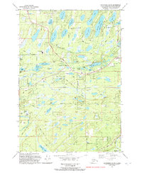
1992 Map of Anchorage C-8 SE
USGS Topo · Published 1992About this map
The Corporate Boundary Houston bisects this lake-strewn landscape in the Matanuska-Susitna Borough, where suburban development begins to press against the Alaskan wilderness. Centered on the George Parks Highway, the area shows a distinct transition from the concentrated residential and educational hub of Houston and the Houston Jr and Sr High Sch to more remote homesteads accessed via the Hollywood Road. A complex network of kettle lakes, including Bear Paw Lake, Prator Lake, and Herning Lake (Seymour Lake), dominates the topography. This 1990s-era snapshot documents the infrastructure of the Susitna Valley, featuring numerous Gravel Pits used for road construction and private aviation facilities like the Settlers Bay Landing Strip near Goose Bay and the Knik Arm shoreline.
Find a feature on this map
52 named features on this map. Tap any name to fly to it.
Don’t see what you’re looking for? This feature index may not catch every label — zoom into the map to look around manually.
Map Details
Editions of this 1992 Anchorage C-8 SE Map
This is the sole edition of this map. No revisions or reprints were ever made.
Other maps of this area

1950 · Anchorage C-8
USGS Topo · 1:63,360

1950 · Anchorage C-7
USGS Topo · 1:63,360

1951 · Anchorage
USGS Topo · 1:250,000

1951 · Anchorage C-7
USGS Topo · 1:63,360

1952 · Anchorage C-7
USGS Topo · 1:63,360

1952 · Anchorage C-8
USGS Topo · 1:63,360

1952 · Anchorage B-8
USGS Topo · 1:63,360

1953 · Anchorage B-8
USGS Topo · 1:63,360

1960 · Anchorage B-7
USGS Topo · 1:63,360

1962 · Anchorage
USGS Topo · 1:250,000