1952 Map of Anderson
USGS Topo · Published 1954About this map
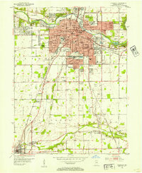
The White River anchors this mid-century view of industrial and residential expansion in Madison County, where the urban grid of Anderson meets suburban developments like Woodlawn Heights and Meadowbrook. The landscape is deeply influenced by the transit corridors of the Ny C RR and Pennsylvania RR, which supported the city's heavy industry and the Municipal Power Plant. To the south, the transition from urban to rural is marked by smaller settlements such as New Columbus and Huntsville, alongside the distinctive Baby Farms and the Sun Valley Speedway. This era shows a community in flux, balancing established neighborhoods like North Anderson with new infrastructure like the Ace Airport and Anderson Memorial Park. Genealogists will find a dense concentration of local burial grounds, including West Maplewood Cem and Harmeson Cem.
Find a feature on this map
78 named features on this map. Tap any name to fly to it.
Don’t see what you’re looking for? This feature index may not catch every label — zoom into the map to look around manually.
Map Details
Editions of this 1952 Anderson Map
This is the sole edition of this map. No revisions or reprints were ever made.
Historical Maps of Anderson Through Time
1 maps found