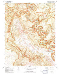
1994 Map of Anderson Mesa
USGS Topo · Published 1994About this map
The Dolores River carves a dramatic, winding path through this corner of the Colorado plateau, separating high tablelands like Anderson Mesa and Skein Mesa. The landscape is defined by its industrial utility, marked by numerous mineral extraction sites scattered across the ridges and canyon walls. Prospectors and mining operations such as the Morning Star Mine, Raven Mine, and American Eagle Mine reflect the region's history of hard-rock and uranium mining.
Find a feature on this map
30 named features on this map. Tap any name to fly to it.
Don’t see what you’re looking for? This feature index may not catch every label — zoom into the map to look around manually.
Map Details
Editions of this 1994 Anderson Mesa Map
This is the sole edition of this map. No revisions or reprints were ever made.
Other maps of this area

1885 · La Sal
USGS Topo · 1:250,000

1916 · Paradox Valley
USGS Topo · 1:125,000

1922 · Paradox Valley
USGS Topo · 1:125,000

1948 · Bull Canyon
USGS Topo · 1:24,000

1948 · Horse Range Mesa
USGS Topo · 1:24,000

1948 · Hamm Canyon
USGS Topo · 1:24,000

1948 · Paradox
USGS Topo · 1:24,000

1949 · Bull Canyon
USGS Topo · 1:24,000

1949 · Davis Mesa
USGS Topo · 1:24,000

1949 · Paradox
USGS Topo · 1:24,000