
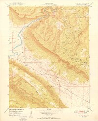
1949 Map of Davis Mesa
USGS Topo · Published 1949About this map
The United States Atomic Energy Commission collaborated on this 1940s survey, highlighting the industrial priority of the region's mineral wealth. A dense concentration of mining operations sits east of Paradox Valley, with named sites such as the Tramp No 2 Mine, Tripod Mine, and Coloradium Mine illustrating the post-war uranium and vanadium boom. These workings are clustered along Long Park Road, providing a clear record of the transportation network required to service the canyon country's remote extraction points.
Find a feature on this map
28 named features on this map. Tap any name to fly to it.
Don’t see what you’re looking for? This feature index may not catch every label — zoom into the map to look around manually.
Map Details
Editions of this 1949 Davis Mesa Map
2 editions found
Other maps of this area

1916 · Paradox Valley
USGS Topo · 1:125,000

1922 · Paradox Valley
USGS Topo · 1:125,000

1948 · Roc Creek
USGS Topo · 1:24,000

1948 · Bull Canyon
USGS Topo · 1:24,000

1948 · Uravan
USGS Topo · 1:24,000

1948 · Naturita NW
USGS Topo · 1:24,000

1948 · Paradox
USGS Topo · 1:24,000

1949 · Bull Canyon
USGS Topo · 1:24,000

1949 · Uravan
USGS Topo · 1:24,000

1949 · Paradox
USGS Topo · 1:24,000