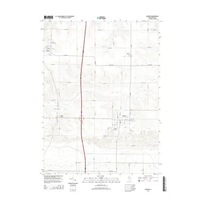
2015 Map of Andover
USGS Topo · Published 2015About this map
Andover and Lynn Center anchor this 2015 survey of Henry County, Illinois, where the landscape is defined by the broad drainage basins of the Edwards River and the S Edwards River. The map records a rural interior punctuated by small settlements and established burial grounds, including the Andover Township Cem and the Presbyterian Cem situated within the community of Andover itself. Further north, the village of Osco sits along the Osco Rd corridor near the headwaters of W Mineral Cr.
Find a feature on this map
59 named features on this map. Tap any name to fly to it.
Don’t see what you’re looking for? This feature index may not catch every label — zoom into the map to look around manually.
Map Details
Editions of this 2015 Andover Map
This is the sole edition of this map. No revisions or reprints were ever made.
Other maps of this area

1931 · Galva
USGS Topo · 1:48,000

1934 · Geneseo
USGS Topo · 1:62,500

1937 · Orion
USGS Topo · 1:62,500

1940 · Galva
USGS Topo · 1:62,500

1944 · Galva
USGS Topo · 1:62,500

1947 · Woodhull
USGS Topo · 1:62,500

1949 · Coal Valley
USGS Topo · 1:24,000
1953 · Coal Valley
USGS Topo · 1:24,000

1953 · Nekoma
USGS Topo · 1:24,000

1953 · Woodhull
USGS Topo · 1:24,000