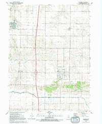
1991 Map of Andover
USGS Topo · Published 1992About this map
Agricultural fields and drainage networks characterize this portion of Henry County, where the Edwards River and South Edwards River meander through the southern landscape. The village of Andover serves as a central hub, flanked by several smaller clusters including Orion to the northwest and Osco to the northeast. Transportation history is etched into the terrain by the Old Railroad Grade, which runs horizontally across the northern townships of Western and Osco. This infrastructure, alongside the Osco-Andover Road, illustrates the historical movement of goods and people between these prairie settlements.
Find a feature on this map
21 named features on this map. Tap any name to fly to it.
Don’t see what you’re looking for? This feature index may not catch every label — zoom into the map to look around manually.
Map Details
Editions of this 1991 Andover Map
This is the sole edition of this map. No revisions or reprints were ever made.
Other maps of this area

1931 · Galva
USGS Topo · 1:48,000

1934 · Geneseo
USGS Topo · 1:62,500

1937 · Orion
USGS Topo · 1:62,500

1940 · Galva
USGS Topo · 1:62,500

1944 · Galva
USGS Topo · 1:62,500

1947 · Woodhull
USGS Topo · 1:62,500

1949 · Coal Valley
USGS Topo · 1:24,000
1953 · Coal Valley
USGS Topo · 1:24,000

1953 · Nekoma
USGS Topo · 1:24,000

1953 · Woodhull
USGS Topo · 1:24,000