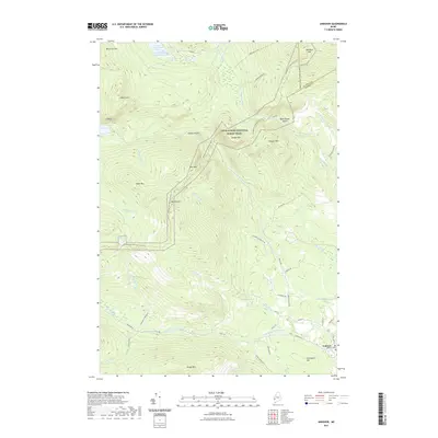
2021 Map of Andover
USGS Topo · Published 2021About this map
The town of Andover serves as a gateway to the high peaks and remote water bodies of Oxford County in this contemporary survey. To the north, the Appalachian National Scenic Trail winds along a dramatic ridgeline, crossing summits like Old Blue Mtn and Wyman Mtn while skirting the depths of Sawyer Notch. The landscape is defined by the drainage of the West Branch Ellis River and its numerous tributaries, including Moody Brook and Stony Brook. Genealogists and local historians can locate the Andover Cem at the edge of the settlement, which remains clustered near the intersection of Main St and Upton Rd. The map documents a rugged interior geography where landmarks like The Cataracts and high-elevation waters such as C Pond and Surplus Pond are connected by a network of logging roads and scenic trails.
Find a feature on this map
59 named features on this map. Tap any name to fly to it.
Don’t see what you’re looking for? This feature index may not catch every label — zoom into the map to look around manually.
Map Details
Editions of this 2021 Andover Map
This is the sole edition of this map. No revisions or reprints were ever made.
Other maps of this area

1927 · Rumford
USGS Topo · 1:48,000

1930 · Rumford
USGS Topo · 1:62,500

1933 · Rangeley
USGS Topo · 1:48,000

1939 · Rangeley
USGS Topo · 1:62,500

1940 · Oquossoc
USGS Topo · 1:62,500

1942 · Oquossoc
USGS Topo · 1:62,500

1943 · Old Speck Mtn
USGS Topo · 1:62,500

1945 · Old Speck Mtn
USGS Topo · 1:62,500

1949 · Rangeley
USGS Topo · 1:62,500

1950 · Lewiston
USGS Topo · 1:250,000