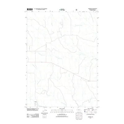
2011 Map of Andrews
USGS Topo · Published 2011About this map
Andrews sits in the southwestern corner of this Nebraska landscape, where the White River and Andrews Rd converge. This 2011 survey by the U.S. Geological Survey details a drainage system defined by the South Fork Soldier Creek and the long, winding path of Soldier Spring Creek. The map shows a landscape primarily shaped by its waterways and a network of rural roads such as Cottonwood Rd and E Hat Creek Rd, illustrating the persistence of ranching and transit patterns in Sioux County. The intricate branching of Tucker Creek and Middle Fork Soldier Creek in the northern reaches highlights the undulating plains that define this portion of the High Plains, providing a clear view of the topography before these waters eventually join larger systems.
Find a feature on this map
11 named features on this map. Tap any name to fly to it.
Don’t see what you’re looking for? This feature index may not catch every label — zoom into the map to look around manually.
Map Details
Editions of this 2011 Andrews Map
This is the sole edition of this map. No revisions or reprints were ever made.
Other maps of this area

1955 · Alliance
USGS Topo · 1:250,000

1957 · Alliance
USGS Topo · 1:250,000

1958 · Alliance
USGS Topo · 1:250,000

1979 · Harrison SE
USGS Topo · 1:24,000

1979 · Harrison East
USGS Topo · 1:24,000

1980 · Kyle Creek
USGS Topo · 1:24,000

1980 · Smiley Canyon
USGS Topo · 1:24,000

1980 · Five Points
USGS Topo · 1:24,000

1980 · Andrews
USGS Topo · 1:24,000
1980 · Roundtop
USGS Topo · 1:24,000