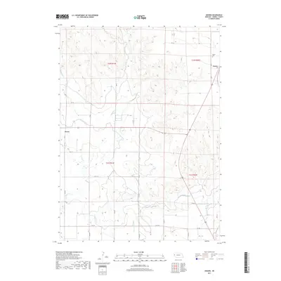
2017 Map of Angora
USGS Topo · Published 2017About this map
The small settlement of Perrin and the community of Angora define the residential character of this western Nebraska landscape in Morrill County. The terrain is deeply influenced by a complex network of water management, with the Tri-State Canal, Lowline Canal, and Northport Canal traversing the plains to support regional agriculture. These man-made waterways interact with natural drainage systems like Red Willow Cr, W Water Cr, and Indian Cr, illustrating the effort to tame the arid environment for cultivation. For those researching local heritage, the Angora Cem serves as a primary point of interest in the northeastern portion of the map. The grid of rural routes, including Co RD 110 and Co RD 87, provides a detailed look at land division and property access in the early 21st century.
Find a feature on this map
33 named features on this map. Tap any name to fly to it.
Don’t see what you’re looking for? This feature index may not catch every label — zoom into the map to look around manually.
Map Details
Editions of this 2017 Angora Map
This is the sole edition of this map. No revisions or reprints were ever made.
Other maps of this area

1898 · Camp Clarke
USGS Topo · 1:125,000

1954 · Scottsbluff
USGS Topo · 1:250,000

1958 · Scottsbluff
USGS Topo · 1:250,000

1965 · Bayard
USGS Topo · 1:24,000

1965 · Bridgeport NW
USGS Topo · 1:24,000
1965 · Bayard NE
USGS Topo · 1:24,000

1965 · Angora SE
USGS Topo · 1:24,000

1965 · South Bayard
USGS Topo · 1:24,000
1965 · Angora NE
USGS Topo · 1:24,000
1965 · Angora NW
USGS Topo · 1:24,000