
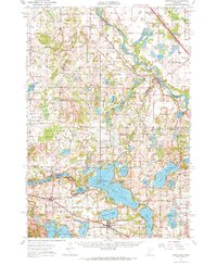
1951 Map of Annandale
USGS Topo · Published 1953About this map
The Mississippi River winds along the northeastern corner of this 1951 study, serving as a natural boundary where Stearns and Wright Counties meet. The landscape is dominated by a dense network of glacial lakes, most notably the expansive Clearwater Lake with its central Bungalow Island. Settlement patterns are defined by small rural hubs like Annandale, South Haven, and Clearwater, which were connected by the Great Northern and Northern Pacific railroads.
Find a feature on this map
100 named features on this map. Tap any name to fly to it.
Don’t see what you’re looking for? This feature index may not catch every label — zoom into the map to look around manually.
Map Details
Editions of this 1951 Annandale Map
2 editions found
Other maps of this area

1950 · St. Cloud
USGS Topo · 1:62,500

1953 · Saint Cloud
USGS Topo · 1:250,000

1953 · Stillwater
USGS Topo · 1:250,000

1955 · Stillwater
USGS Topo · 1:250,000

1957 · Saint Cloud
USGS Topo · 1:250,000

1958 · Stillwater
USGS Topo · 1:250,000

1958 · Saint Cloud
USGS Topo · 1:250,000

1958 · Dassel
USGS Topo · 1:62,500

1958 · Buffalo
USGS Topo · 1:62,500

1958 · Cokato
USGS Topo · 1:62,500