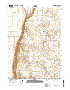
2017 Map of Antelope Butte
USGS Topo · Published 2017About this map
Antelope Butte and its neighboring volcanic peaks dominate this high desert landscape in Lake County, Oregon. The terrain is characterized by dramatic escarpments and interior drainage basins, most notably where the Guano Rim overlooks the expansive Guano Valley. This 2017 survey illustrates a sparse network of infrastructure where water sources are the primary landmarks. Essential water points such as Slide Waterhole, Snake Eyes Spring, and Lane Spring are vital features in this arid environment. Transportation through the area relies on unpaved routes like Beattys Butte Rd, which skirts the base of the ridges. The map also captures significant landforms including Sage Hen Butte and the sharp descent of the Doherty Slide, providing a clear record of the geological and hydrological character of this portion of the Oregon high desert.
Find a feature on this map
18 named features on this map. Tap any name to fly to it.
Don’t see what you’re looking for? This feature index may not catch every label — zoom into the map to look around manually.
Map Details
Editions of this 2017 Antelope Butte Map
This is the sole edition of this map. No revisions or reprints were ever made.
Other maps of this area

1889 · Long Valley
USGS Topo · 1:250,000

1954 · Vya
USGS Topo · 1:250,000

1955 · Adel
USGS Topo · 1:250,000

1957 · Adel
USGS Topo · 1:250,000

1958 · Vya
USGS Topo · 1:250,000

1958 · Adel
USGS Topo · 1:250,000

1962 · Vya
USGS Topo · 1:250,000

1962 · Adel
USGS Topo · 1:250,000

1966 · Catnip Canyon
USGS Topo · 1:24,000
1966 · Rye Creek
USGS Topo · 1:24,000