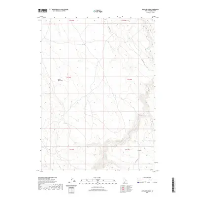
2020 Map of Antelope Creek
USGS Topo · Published 2020About this map
Broken Wagon Draw carves through this corner of Owyhee County, providing a glimpse into the topographical features of the Idaho desert in the early twenty-first century. The landscape is characterized by its drainage systems, with Sheep Cr and Cat Cr winding through the high plateau. The presence of Rowland Rt Rd suggests a network of access through this part of the J-P Desert, a region largely defined by its sparse human infrastructure and vast grazing lands. This map details the township and range divisions, including t14s r5e and t15s r6e, which anchor the land ownership and survey history of the western rangelands. It is a portrait of a working landscape where water sources and named draws like Broken Wagon Draw remain the primary landmarks for navigation and land management.
Find a feature on this map
11 named features on this map. Tap any name to fly to it.
Don’t see what you’re looking for? This feature index may not catch every label — zoom into the map to look around manually.
Map Details
Editions of this 2020 Antelope Creek Map
This is the sole edition of this map. No revisions or reprints were ever made.
Other maps of this area

1955 · Twin Falls
USGS Topo · 1:250,000

1958 · Twin Falls
USGS Topo · 1:250,000
1979 · Antelope Creek
USGS Topo · 1:24,000

1979 · Indian Hot Springs
USGS Topo · 1:24,000
1979 · Indian Hay Meadows
USGS Topo · 1:24,000
1979 · Triguero Lake
USGS Topo · 1:24,000
1979 · Grasmere Reservoir
USGS Topo · 1:24,000
1979 · Triplet Butte
USGS Topo · 1:24,000
1979 · Black Leg Creek
USGS Topo · 1:24,000
1979 · Buster Butte
USGS Topo · 1:24,000