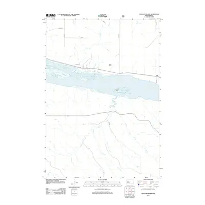
2012 Map of Antelope Island
USGS Topo · Published 2012About this map
Lake Sharpe dominates the center of this Missouri River reservoir landscape, where the waters surround the landform of Antelope Island. The small settlement of Alto sits on the northern bank, connected by a network of rural routes such as Nystrom Rd and Lakeview Pl. The terrain is defined by a series of drainage systems that feed into the main waterway, including the winding paths of Mush Cr and Cherry Cr from the north, and the more extensive Antelope Cr, Timber Cr, and Sand Cr systems arriving from the south. This mapping reveals the modern balance between the managed reservoir environment and the traditional agricultural road grid of Hughes County, featuring local landmarks like Taylor Draw.
Find a feature on this map
19 named features on this map. Tap any name to fly to it.
Don’t see what you’re looking for? This feature index may not catch every label — zoom into the map to look around manually.
Map Details
Editions of this 2012 Antelope Island Map
This is the sole edition of this map. No revisions or reprints were ever made.
Other maps of this area

1924 · Pierre
USGS Topo · 1:62,500

1934 · Canning
USGS Topo · 1:48,000

1937 · Canning
USGS Topo · 1:62,500

1954 · Pierre
USGS Topo · 1:250,000

1958 · Pierre
USGS Topo · 1:250,000

1967 · Pierre NE
USGS Topo · 1:24,000

1967 · Canning
USGS Topo · 1:24,000
1967 · Canning NW
USGS Topo · 1:24,000

1967 · Ft. George Butte NW
USGS Topo · 1:24,000
1967 · Ft. George Butte
USGS Topo · 1:24,000