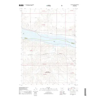
2017 Map of Antelope Island
USGS Topo · Published 2017About this map
Lake Sharpe and the Missouri River define the central axis of this landscape, separating the prairie uplands of Hughes and Stanley counties. The water is punctuated by Antelope Island and Farm Island, landmarks that shift the river's flow through this central South Dakota corridor. To the south, the terrain transitions into the expansive Fort Pierre National Grassland, a massive tract of protected prairie that covers the lower half of the map. The settlement of Alto is situated on the eastern edge, near where Mosteller Draw meets the river valley. Numerous drainage features such as Mush Cr, Antelope Cr, and Sand Cr carve through the draws and ridges, including the prominent Royal Ridge. This survey documents a rural landscape where local infrastructure like Antelope Creek Rd and Nystrom Rd provides access through the deeply eroded breaks along the river.
Find a feature on this map
30 named features on this map. Tap any name to fly to it.
Don’t see what you’re looking for? This feature index may not catch every label — zoom into the map to look around manually.
Map Details
Editions of this 2017 Antelope Island Map
This is the sole edition of this map. No revisions or reprints were ever made.
Other maps of this area

1924 · Pierre
USGS Topo · 1:62,500

1934 · Canning
USGS Topo · 1:48,000

1937 · Canning
USGS Topo · 1:62,500

1954 · Pierre
USGS Topo · 1:250,000

1958 · Pierre
USGS Topo · 1:250,000

1967 · Pierre NE
USGS Topo · 1:24,000

1967 · Canning
USGS Topo · 1:24,000
1967 · Canning NW
USGS Topo · 1:24,000

1967 · Ft. George Butte NW
USGS Topo · 1:24,000
1967 · Ft. George Butte
USGS Topo · 1:24,000