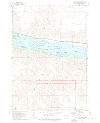
1973 Map of Antelope Island
USGS Topo · Published 1976About this map
The Old Indian Treaty Boundary slices through the southern portion of this landscape, marking a significant historical line across the rugged terrain of Stanley and Hughes Counties. In the early 1970s, the Missouri River corridor is dominated by the waters of Lake Sharpe, which surrounds landforms such as Antelope Island and Farm Island. The northern bank is defined by the infrastructure of the Chicago and North Western railroad, which runs parallel to the river through small stops like Alto and near Pleasant. This survey captures the region after the construction of dams altered the river's flow, creating Hipple Lake and providing for the Antelope-Creek Recreation Area. The map reveals a transition from the industrial rail line and gravel pits in the north to the deeply eroded drainages of Timber Creek and Sand Creek in the south.
Find a feature on this map
22 named features on this map. Tap any name to fly to it.
Don’t see what you’re looking for? This feature index may not catch every label — zoom into the map to look around manually.
Map Details
Editions of this 1973 Antelope Island Map
This is the sole edition of this map. No revisions or reprints were ever made.
Other maps of this area

1924 · Pierre
USGS Topo · 1:62,500

1934 · Canning
USGS Topo · 1:48,000

1937 · Canning
USGS Topo · 1:62,500

1954 · Pierre
USGS Topo · 1:250,000

1958 · Pierre
USGS Topo · 1:250,000

1967 · Pierre NE
USGS Topo · 1:24,000

1967 · Canning
USGS Topo · 1:24,000
1967 · Canning NW
USGS Topo · 1:24,000

1967 · Ft. George Butte NW
USGS Topo · 1:24,000
1967 · Ft. George Butte
USGS Topo · 1:24,000