1911 Map of Antelope
USGS Topo · Published 1911About this map
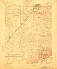
Roseville sits at a critical junction in this early 20th-century landscape, where the Southern Pacific R. R. Ogden Line cuts a straight diagonal through the rolling country north of the American River. The map captures the transition from the rail-oriented growth in the north to the established rural communities like Fairoaks in the south, connected by the Fairoaks Bridge. Land grants such as the Paso Del San Juan and the Rio De Los Americanos provide the underlying framework for the parceling of the territory. Notable local landmarks for researchers include the Twelvemile House along the Auburn Road, while the presence of both the Sylvan School and San Juan School indicates the early educational infrastructure serving the scattered farmsteads. Smaller watercourses like Linda Creek, Antelope Creek, and Chicken Ranch Slough trace the natural drainage patterns that shaped the placement of original settlements and routes.
Find a feature on this map
20 named features on this map. Tap any name to fly to it.
Don’t see what you’re looking for? This feature index may not catch every label — zoom into the map to look around manually.
Map Details
Editions of this 1911 Antelope Map
This is the sole edition of this map. No revisions or reprints were ever made.
Other maps of this area

1891 · Sacramento
USGS Topo · 1:125,000

1892 · Sacramento
USGS Topo · 1:125,000

1893 · Sacramento
USGS Topo · 1:125,000

1902 · Fairoaks
USGS Topo · 1:62,500

1908 · Buffalo Creek
USGS Topo · 1:31,680

1910 · Roseville
USGS Topo · 1:31,680

1910 · Pleasant Grove
USGS Topo · 1:31,680

1911 · Brighton
USGS Topo · 1:31,680

1911 · Mills
USGS Topo · 1:31,680

1911 · Arcade
USGS Topo · 1:31,680