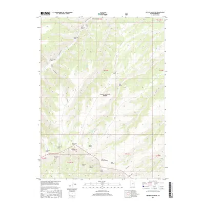
2017 Map of Anthro Mountain
USGS Topo · Published 2017About this map
Anthro Mountain dominates the southern reaches of this Duchesne County landscape, marking a significant vertical transition within the Ashley National Forest. This high-altitude terrain is defined by a complex network of drainage systems, where Sowers Cr flows through the northern canyons and seasonal sources like Mine Hollow Spring and Nutters Spring provided critical water in an arid environment. The map captures the dramatic topography of the Bad Land Cliffs and the narrow passage known as The Squeeze, illustrating the natural barriers that shaped movement through the region. Historical access is traced through primitive routes such as Sowers Canyon Rd and Quitchampau, which navigate between prominent landforms like Brundage Canyon and Wolf Hollow. The concentration of named hollows, including North Lost Hollow and South Twin Hollow, reflects a detailed vernacular geography used by early ranchers and forest rangers to navigate these high plateaus.
Find a feature on this map
35 named features on this map. Tap any name to fly to it.
Don’t see what you’re looking for? This feature index may not catch every label — zoom into the map to look around manually.
Map Details
Editions of this 2017 Anthro Mountain Map
This is the sole edition of this map. No revisions or reprints were ever made.
Other maps of this area

1885 · Uinta
USGS Topo · 1:250,000

1886 · Price River
USGS Topo · 1:250,000

1896 · Price River
USGS Topo · 1:250,000

1939 · Duchesne
USGS Topo · 1:125,000

1954 · Salt Lake City
USGS Topo · 1:250,000

1956 · Price
USGS Topo · 1:250,000

1958 · Salt Lake City
USGS Topo · 1:250,000

1960 · Salt Lake City
USGS Topo · 1:250,000

1960 · Price
USGS Topo · 1:250,000

1962 · Price
USGS Topo · 1:250,000