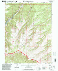
1996 Map of Anthro Mountain
USGS Topo · Published 1999About this map
Ashley National Forest dominates this section of the Uinta Basin, defined by the sharp topographical descent from Anthro Mountain into the labyrinthine drainages of the Bad Land Cliffs. The landscape is etched by a series of deep canyons, including Nutters Canyon, Brundage Canyon, and the sprawling Sowers Canyon. This 1990s revision reveals a land utilized for both resource extraction and livestock management, evidenced by numerous Drill Holes, an Oil Well, and the Cracker Grove settlement. Water remains a critical and scarce resource in this arid environment, marked by isolated points like Mine Hollow Spring and a Gaging Station along the canyon floors. The map also captures the intersection of major survey lines, including the Uintah Special Meridian and the West First Guide Meridian.
Find a feature on this map
26 named features on this map. Tap any name to fly to it.
Don’t see what you’re looking for? This feature index may not catch every label — zoom into the map to look around manually.
Map Details
Editions of this 1996 Anthro Mountain Map
This is the sole edition of this map. No revisions or reprints were ever made.
Other maps of this area

1885 · Uinta
USGS Topo · 1:250,000

1886 · Price River
USGS Topo · 1:250,000

1896 · Price River
USGS Topo · 1:250,000

1939 · Duchesne
USGS Topo · 1:125,000

1954 · Salt Lake City
USGS Topo · 1:250,000

1956 · Price
USGS Topo · 1:250,000

1958 · Salt Lake City
USGS Topo · 1:250,000

1960 · Salt Lake City
USGS Topo · 1:250,000

1960 · Price
USGS Topo · 1:250,000

1962 · Price
USGS Topo · 1:250,000