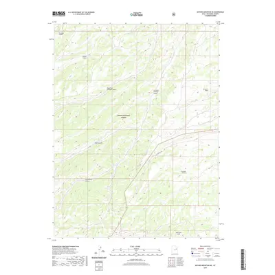
2020 Map of Anthro Mountain NE
USGS Topo · Published 2020About this map
Ashley National Forest covers much of this high-elevation terrain in Duchesne County, where a complex network of canyons drains toward the basin floor. The landscape is defined by the sharp descent from the Bad Land Cliffs in the south toward the lower northern drainages. These natural corridors, including Brundage Canyon, Nutters Canyon, and Alkali Canyon, have long influenced movement through this part of the Uinta Basin. The drainage system of Antelope Cr is particularly prominent, split into distinct branches such as Right Fork Antelope Canyon and Left Fork Antelope Canyon. Evidence of the region's unique mineral history is found at Gilsonite Draw, reflecting the specific geological resources that drove early development and exploration in this remote portion of Utah. The transition from high cliff edges to deep canyon floors is bridged by routes like Five Mile Draw Rd.
Find a feature on this map
12 named features on this map. Tap any name to fly to it.
Don’t see what you’re looking for? This feature index may not catch every label — zoom into the map to look around manually.
Map Details
Editions of this 2020 Anthro Mountain NE Map
This is the sole edition of this map. No revisions or reprints were ever made.
Other maps of this area

1885 · Uinta
USGS Topo · 1:250,000

1886 · Price River
USGS Topo · 1:250,000

1896 · Price River
USGS Topo · 1:250,000

1939 · Duchesne
USGS Topo · 1:125,000

1954 · Salt Lake City
USGS Topo · 1:250,000

1956 · Price
USGS Topo · 1:250,000

1958 · Salt Lake City
USGS Topo · 1:250,000

1960 · Salt Lake City
USGS Topo · 1:250,000

1960 · Price
USGS Topo · 1:250,000

1962 · Price
USGS Topo · 1:250,000