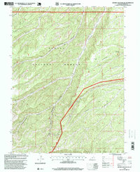
1996 Map of Anthro Mountain NE
USGS Topo · Published 1999About this map
Ashley National Forest dominates this high-elevation landscape in Duchesne County, where deep canyons drain toward the north. The drainage system is defined by the convergence of Left Fork Antelope Canyon and Right Fork Antelope Canyon, forming the primary Antelope Canyon corridor. To the south, the terrain rises sharply toward the Bad Land Cliffs, a significant geological barrier. The 1996 survey data reveals a landscape primarily managed for natural resources and conservation, though scattered industrial activity is evident. Scattered markers for an Oil Well and several Drill Hole locations, particularly near Gilsonite Draw and Alkali Canyon, indicate energy exploration within the forest boundaries. The map also records early prospecting efforts with a Prospect label, highlighting the region's long-standing connection to mineral and fuel extraction amid its complex canyon topography.
Find a feature on this map
22 named features on this map. Tap any name to fly to it.
Don’t see what you’re looking for? This feature index may not catch every label — zoom into the map to look around manually.
Map Details
Editions of this 1996 Anthro Mountain NE Map
This is the sole edition of this map. No revisions or reprints were ever made.
Other maps of this area

1885 · Uinta
USGS Topo · 1:250,000

1886 · Price River
USGS Topo · 1:250,000

1896 · Price River
USGS Topo · 1:250,000

1939 · Duchesne
USGS Topo · 1:125,000

1954 · Salt Lake City
USGS Topo · 1:250,000

1956 · Price
USGS Topo · 1:250,000

1958 · Salt Lake City
USGS Topo · 1:250,000

1960 · Salt Lake City
USGS Topo · 1:250,000

1960 · Price
USGS Topo · 1:250,000

1962 · Price
USGS Topo · 1:250,000