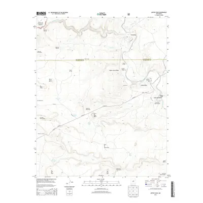
2013 Map of Anton Chico
USGS Topo · Published 2013About this map
The Pecos River carves a winding path through this corner of New Mexico, supporting a series of historic riverside settlements along its banks. The map highlights the traditional agricultural infrastructure of the region, specifically the Hormigoso Irrigation Ditch and Dam that serves the communities of Upper Anton Chico and Anton Chico. This area, where the San Miguel and Guadalupe county line meets, is characterized by its significant Hispanic settlement heritage, evident in the cluster of plazas and llanos like Llano del Medio and Llano Viejo. For genealogists, the Old Anton Chico Cem provides a specific point of interest near the river's bend. To the west, the landscape rises into the high mesas and canyons of the Santa Fe National Forest, with prominent landmarks such as Ben Ortiz Peak and the Mesa de la Chamizalosa overlooking the valley.
Find a feature on this map
49 named features on this map. Tap any name to fly to it.
Don’t see what you’re looking for? This feature index may not catch every label — zoom into the map to look around manually.
Map Details
Editions of this 2013 Anton Chico Map
This is the sole edition of this map. No revisions or reprints were ever made.
Other maps of this area

1890 · Bernal
USGS Topo · 1:125,000

1891 · Bernal
USGS Topo · 1:125,000

1894 · Bernal
USGS Topo · 1:125,000

1954 · Santa Fe
USGS Topo · 1:250,000

1958 · Santa Fe
USGS Topo · 1:250,000

1960 · Villanueva
USGS Topo · 1:62,500

1960 · Apache Springs
USGS Topo · 1:62,500
1963 · Thompson Ranch
USGS Topo · 1:24,000
1963 · Anton Chico
USGS Topo · 1:24,000
1963 · Mesa Palo Amarillo
USGS Topo · 1:24,000