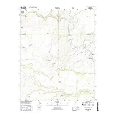
2017 Map of Anton Chico
USGS Topo · Published 2017About this map
The Pecos River carves a deep valley through this high desert landscape, anchoring the historic riverside settlements of Anton Chico, Upper Anton Chico, and Tecolotito. The map reveals the intricate network of traditional land divisions and irrigation patterns characteristic of this region, where the river valley transitions into the elevated plains of Llano Largo and Llano del Medio. Genealogists will note the Old Anton Chico Cem located near the village center. The terrain is defined by dramatic geological features including Mesa de la Chamizalosa and the prominent Ben Ortiz Peak. Remote ranching infrastructure is visible through numerous water catchments such as Montecitos Tank and Frank Padilla Tank, while the northwestern corner reaches into the Santa Fe National Forest near Cañon de Valencia.
Find a feature on this map
51 named features on this map. Tap any name to fly to it.
Don’t see what you’re looking for? This feature index may not catch every label — zoom into the map to look around manually.
Map Details
Editions of this 2017 Anton Chico Map
This is the sole edition of this map. No revisions or reprints were ever made.
Other maps of this area

1890 · Bernal
USGS Topo · 1:125,000

1891 · Bernal
USGS Topo · 1:125,000

1894 · Bernal
USGS Topo · 1:125,000

1954 · Santa Fe
USGS Topo · 1:250,000

1958 · Santa Fe
USGS Topo · 1:250,000

1960 · Villanueva
USGS Topo · 1:62,500

1960 · Apache Springs
USGS Topo · 1:62,500
1963 · Thompson Ranch
USGS Topo · 1:24,000
1963 · Anton Chico
USGS Topo · 1:24,000
1963 · Mesa Palo Amarillo
USGS Topo · 1:24,000