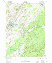
1949 Map of Antwerp
USGS Topo · Published 1974About this map
The Indian River winds through the heart of this post-war landscape, where the village of Antwerp sits at a critical junction of the New York Central Railroad. To the south and east, a massive portion of the quadrangle is occupied by the Pine Camp Military Reservation, a site defined by its specialized infrastructure like the Rifle Range and an extensive network of patrol roads including Camp Road and Rockwell Road. The civilian landscape north of the military boundary preserves a rural character rooted in early education and local history, evidenced by School No 3 and School No 15. The rugged borderlands between Jefferson, Lewis, and St. Lawrence counties are clearly delineated, showing how the military installation integrated with established townships like Wilna and Diana. Notable local landmarks such as Hillside Cem and the drainage of Matoon Creek provide fine-grained detail for genealogical research and land-use studies.
Find a feature on this map
29 named features on this map. Tap any name to fly to it.
Don’t see what you’re looking for? This feature index may not catch every label — zoom into the map to look around manually.
Map Details
Editions of this 1949 Antwerp Map
2 editions found
Other maps of this area

1911 · Antwerp
USGS Topo · 1:62,500

1912 · Hammond
USGS Topo · 1:62,500

1913 · Lake Bonaparte
USGS Topo · 1:62,500

1915 · Gouverneur
USGS Topo · 1:62,500

1916 · Lake Bonaparte
USGS Topo · 1:62,500

1937 · Gouverneur
USGS Topo · 1:62,500

1944 · Hammond
USGS Topo · 1:62,500

1948 · Ogdensburg
USGS Topo · 1:250,000

1949 · Hammond
USGS Topo · 1:62,500

1949 · Antwerp
USGS Topo · 1:62,500