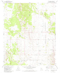
1980 Map of Anvil Rock
USGS Topo · Published 1980About this map
Anvil Rock stands as a prominent landmark in this high-desert region of Yavapai County, where the southern reaches of the Juniper Mountains meet the expansive cattle-country lowlands. The 1980 landscape is defined by the massive Luis Maria Baca Float No 5 land grant boundary, a legacy of Spanish and Mexican land claims that complicates modern surveying. Ranching infrastructure dominates the water-scarce terrain, with numerous named catchments such as Henry Brown Tank, Smith and Evans Tank, and Windy Roberts Tank serving as vital hubs for livestock. Transient habitations like New Water Line Camp and E L Camp suggest the seasonal nature of work in this corner of the Prescott National Forest. Along the western edge, drainage is channeled through Muddy Creek and Hope Wash, while a lonely Radio Facility and various Jeep Trails provide the only modern technological imprints on the terrain.
Find a feature on this map
22 named features on this map. Tap any name to fly to it.
Don’t see what you’re looking for? This feature index may not catch every label — zoom into the map to look around manually.
Map Details
Editions of this 1980 Anvil Rock Map
This is the sole edition of this map. No revisions or reprints were ever made.
Other maps of this area

1886 · Diamond Creek
USGS Topo · 1:250,000

1886 · Chino
USGS Topo · 1:250,000

1887 · Prescott
USGS Topo · 1:250,000

1891 · Chino
USGS Topo · 1:250,000

1892 · Diamond Creek
USGS Topo · 1:250,000

1892 · Prescott
USGS Topo · 1:250,000

1923 · Signal
USGS Topo · 1:250,000

1942 · Signal
USGS Topo · 1:250,000

1947 · Turkey Canyon
USGS Topo · 1:62,500

1947 · Camp Wood
USGS Topo · 1:62,500