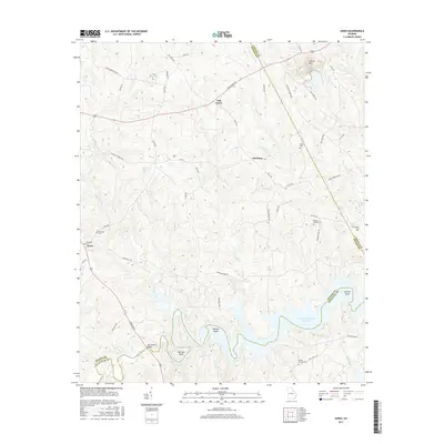
2017 Map of Aonia
USGS Topo · Published 2017About this map
The Little River meanders across this eastern Georgia landscape, defining the jagged border between Wilkes Co and McDuffie Co. Significant bends in the river, such as Busseys Bend and Fish Dam Bend, lead into the sprawling waters of the J. Strom Thurmond Reservoir, which dominates the southeast corner of the map. High ground is marked by the distinct peak of Graves Mtn in the northeast, rising above the surrounding creek valleys and rural road networks. Small rural settlements like Oak Grove, Adasburg, and Aonia serve as local hubs, connected by routes such as Lincolnton Rd and Thomson Rd. Genealogists will find several family and church burial grounds, including Pierces Chapel Cem, Burdette Cem, and the Griffin- Johnson Cemetery, which document the long-standing community ties in this river-and-ridge country.
Find a feature on this map
58 named features on this map. Tap any name to fly to it.
Don’t see what you’re looking for? This feature index may not catch every label — zoom into the map to look around manually.
Map Details
Editions of this 2017 Aonia Map
This is the sole edition of this map. No revisions or reprints were ever made.
Other maps of this area

1892 · Mc Cormick
USGS Topo · 1:125,000

1906 · Crawfordville
USGS Topo · 1:125,000

1912 · Mc Cormick
USGS Topo · 1:125,000

1921 · Appling
USGS Topo · 1:62,500

1943 · Appling
USGS Topo · 1:62,500

1953 · Athens
USGS Topo · 1:250,000

1954 · Metasville
USGS Topo · 1:24,000

1955 · Tignall
USGS Topo · 1:24,000

1958 · Athens
USGS Topo · 1:250,000

1959 · Athens
USGS Topo · 1:250,000