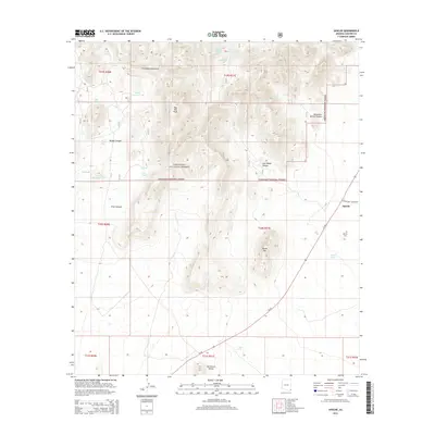
2014 Map of Apache
USGS Topo · Published 2014About this map
Chiricahua Mountains and the arid expanse of the San Simon Valley define this landscape along the Arizona-New Mexico border. The small settlement of Apache sits at the junction of Az 80 and N Skeleton Canyon Rd, a vital crossing point in a region dominated by ranching and high-desert terrain. Much of the western and central portion of the map is managed as part of the Coronado National Forest, where steep drainages like Price Canyon and Brushy Canyon cut through the foothills of May Day Peak. Evidence of the area's essential water management for livestock is scattered throughout, from Jacks Tank in the north to the IV Bar Tank in the south. The proximity of the Apache Cem reflects the deep local history of this frontier outpost, situated where the mountains meet the open valley floor.
Find a feature on this map
35 named features on this map. Tap any name to fly to it.
Don’t see what you’re looking for? This feature index may not catch every label — zoom into the map to look around manually.
Map Details
Editions of this 2014 Apache Map
This is the sole edition of this map. No revisions or reprints were ever made.
Other maps of this area

1917 · Chiricahua
USGS Topo · 1:125,000

1919 · Chiricahua
USGS Topo · 1:125,000

1926 · Rodeo
USGS Topo · 1:62,500

1926 · Rucker
USGS Topo · 1:62,500

1926 · Pedregosa
USGS Topo · 1:62,500

1940 · Apache
USGS Topo · 1:62,500

1955 · Douglas
USGS Topo · 1:250,000

1958 · Chiricahua Peak
USGS Topo · 1:62,500

1958 · Apache
USGS Topo · 1:62,500
1958 · Pedregosa Mountains
USGS Topo · 1:62,500