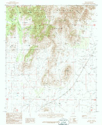
1987 Map of Apache
USGS Topo · Published 1987About this map
Chiricahua Mountains dominate the western half of this landscape within the Coronado National Forest. This 1987 provisional survey documents the intersection of high-desert terrain and early transportation routes in southeastern Arizona. The settlement of Apache is positioned at the base of the mountains, marked by its proximity to an Old Railroad Grade and a Historical Mon. The topography is defined by numerous drainage systems, including Price Canyon, Wood Canyon, and Two-Weeks Spring Canyon. Evidence of land management and ranching is scattered throughout the survey, with a high density of water catchments such as Jacks Tank, Horse Pasture Tank, and IV Bar Tank. Local history markers like a lone Cem and several isolated wells suggest a sparse but established human presence across the basin floor east of Squaw Mountain.
Find a feature on this map
30 named features on this map. Tap any name to fly to it.
Don’t see what you’re looking for? This feature index may not catch every label — zoom into the map to look around manually.
Map Details
Editions of this 1987 Apache Map
This is the sole edition of this map. No revisions or reprints were ever made.
Other maps of this area

1917 · Chiricahua
USGS Topo · 1:125,000

1919 · Chiricahua
USGS Topo · 1:125,000

1926 · Rodeo
USGS Topo · 1:62,500

1926 · Rucker
USGS Topo · 1:62,500

1926 · Pedregosa
USGS Topo · 1:62,500

1940 · Apache
USGS Topo · 1:62,500

1955 · Douglas
USGS Topo · 1:250,000

1958 · Chiricahua Peak
USGS Topo · 1:62,500

1958 · Apache
USGS Topo · 1:62,500
1958 · Pedregosa Mountains
USGS Topo · 1:62,500