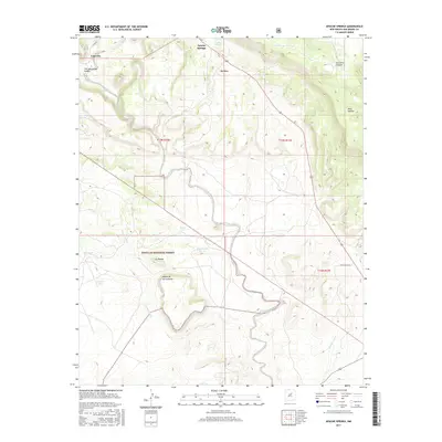
2017 Map of Apache Springs
USGS Topo · Published 2017About this map
Apache Springs and the nearby settlement of Lagunita anchor this portion of San Miguel County, where the high desert terrain transitions into the protected lands of the Santa Fe National Forest. The landscape is defined by a series of prominent mesas and canyons, including Mid Mesa, Mesa Apache, and the deep cuts of Tres Hermanos Canon and La Cueva Canyon. Water management is a critical element of the local geography, evidenced by numerous named tanks such as Red Tank, Boggy Tank, and Ladrones Tank, which support cattle or wildlife in this arid environment. The winding course of Tecolote Creek cuts through the center of the map, while Arroyo Leguino drains the southwestern portion near the distinctive Mesita de los Ladrones. This 2017 survey provides a clear view of the rural infrastructure, including County Road B27, that connects these isolated ranching and forest landscapes.
Find a feature on this map
22 named features on this map. Tap any name to fly to it.
Don’t see what you’re looking for? This feature index may not catch every label — zoom into the map to look around manually.
Map Details
Editions of this 2017 Apache Springs Map
This is the sole edition of this map. No revisions or reprints were ever made.
Other maps of this area

1890 · Bernal
USGS Topo · 1:125,000

1891 · Bernal
USGS Topo · 1:125,000

1894 · Bernal
USGS Topo · 1:125,000

1954 · Santa Fe
USGS Topo · 1:250,000

1958 · Santa Fe
USGS Topo · 1:250,000

1960 · Villanueva
USGS Topo · 1:62,500

1960 · Apache Springs
USGS Topo · 1:62,500
1963 · Anton Chico
USGS Topo · 1:24,000
1963 · Dilia
USGS Topo · 1:24,000
1963 · San Juan
USGS Topo · 1:24,000