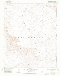
1969 Map of Appaloosa Ridge
USGS Topo · Published 1971About this map
The Navajo Indian Reservation landscape is defined by its sharp geologic breaks and essential water infrastructure in this late-1960s survey. Dominating the upper half of the map, Coal Mine Mesa and the Moenkopi Plateau provide a high, windswept vantage over the intricate drainage systems below, including Chiehazhahi Wash and Big Wash. This region reflects a sparse but purposeful settlement pattern, centered on the Little Hollow Place and livestock management points like the Little Cowboy Windmill.
Find a feature on this map
15 named features on this map. Tap any name to fly to it.
Don’t see what you’re looking for? This feature index may not catch every label — zoom into the map to look around manually.
Map Details
Editions of this 1969 Appaloosa Ridge Map
This is the sole edition of this map. No revisions or reprints were ever made.
Other maps of this area

1883 · Marsh Pass
USGS Topo · 1:250,000

1883 · Tusayan
USGS Topo · 1:250,000

1886 · Tusayan
USGS Topo · 1:250,000

1886 · San Francisco Mtns
USGS Topo · 1:250,000

1886 · Echo Cliffs
USGS Topo · 1:250,000

1891 · San Francisco Mtns
USGS Topo · 1:250,000

1891 · Echo Cliffs
USGS Topo · 1:250,000

1892 · Marsh Pass
USGS Topo · 1:250,000

1894 · San Francisco Mtns
USGS Topo · 1:250,000

1899 · San Francisco Mtns
USGS Topo · 1:250,000