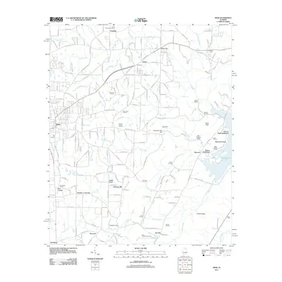
2011 Map of Arab
USGS Topo · Published 2011About this map
Arab and its surrounding Marshall County countryside are defined by a complex network of ridgelines and watercourses during this 2011 survey. The landscape is marked by prominent topographic features such as Dividing Ridge and the water-carved gap at Thompson Falls. Rural communities like Scant City, Friendship, and Hopewell are connected by a dense web of county roads that navigate the varying elevations. The eastern edge of the map shows the shoreline of Guntersville Lake, where modern residential growth is evident in the Point of Pines Subdivision and Sherwood Forest. Genealogists will find a wealth of local burial sites, including the Arab City Cemetery, Shiloh Cemetery, and the Ridgway Cemetery. The presence of several gaps, such as Feemster Gap and Fry Gap, illustrates how the local terrain dictated the historic pathways and modern road alignments through this part of northern Alabama.
Find a feature on this map
213 named features on this map. Tap any name to fly to it.
Don’t see what you’re looking for? This feature index may not catch every label — zoom into the map to look around manually.
Map Details
Editions of this 2011 Arab Map
This is the sole edition of this map. No revisions or reprints were ever made.
Other maps of this area

1885 · Gadsden
USGS Topo · 1:125,000

1888 · Cullman
USGS Topo · 1:125,000

1888 · Gadsden
USGS Topo · 1:125,000

1892 · Cullman
USGS Topo · 1:125,000

1892 · Gadsden
USGS Topo · 1:125,000

1895 · Gadsden
USGS Topo · 1:125,000

1903 · Gadsden
USGS Topo · 1:125,000

1936 · Guntersville
USGS Topo · 1:24,000

1936 · Guntersville Dam
USGS Topo · 1:24,000

1936 · Hulaco
USGS Topo · 1:24,000