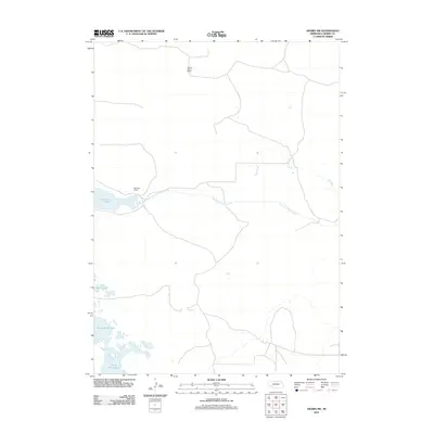
2011 Map of Arabia SW
USGS Topo · Published 2011About this map
Rolling Stone Ranch and Red Deer Ranch anchor the high plains of Cherry County in this survey of the Nebraska Sandhills. The landscape is defined by its complex hydrography, where the winding North Fork Plum Creek and ephemeral Dry Creek navigate the undulating terrain. Significant wetlands and lacustrine features dominate the southern half of the quadrangle, notably the expansive South Marsh Lake, North Marsh Lake, and Red Deer Lake. This 2011 map reflects a region of sparse settlement where the spatial orientation of large cattle ranches remains the primary human footprint. The isolation of these water sources underscores the traditional reliance on natural hydrology for ranching in one of the most remote sections of the American West.
Find a feature on this map
7 named features on this map. Tap any name to fly to it.
Don’t see what you’re looking for? This feature index may not catch every label — zoom into the map to look around manually.
Map Details
Editions of this 2011 Arabia SW Map
This is the sole edition of this map. No revisions or reprints were ever made.
Other maps of this area

1949 · Long Lake
USGS Topo · 1:62,500

1950 · Simeon
USGS Topo · 1:62,500

1950 · Arabia
USGS Topo · 1:62,500

1951 · Long Lake
USGS Topo · 1:62,500

1951 · Brownlee
USGS Topo · 1:62,500

1957 · Valentine
USGS Topo · 1:250,000

1959 · Valentine
USGS Topo · 1:250,000

1985 · Long Lake
USGS Topo · 1:24,000

1985 · Wilson Valley
USGS Topo · 1:24,000
1985 · Arabia SE
USGS Topo · 1:24,000