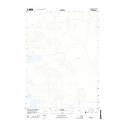
2014 Map of Arabia SW
USGS Topo · Published 2014About this map
North Fork Plum Creek meanders through the heart of this Cherry County landscape, a region defined by its complex hydrology and dramatic sand hills. The map illustrates a series of significant water bodies, including Red Deer Lake and the expansive South Marsh Lake, which characterize the depression-filled terrain typical of the Nebraska Sandhills. These wetlands and seasonal watercourses like Dry Cr suggest a landscape largely shaped by the high water table and local drainage patterns of the early 21st century. The intricate contour lines reveal the undulating topography that separates these low-lying marshlands, while the placement of North Marsh Lake further emphasizes the concentration of ecological preserves and wildlife habitats that dominate this sparsely settled portion of the state.
Find a feature on this map
6 named features on this map. Tap any name to fly to it.
Don’t see what you’re looking for? This feature index may not catch every label — zoom into the map to look around manually.
Map Details
Editions of this 2014 Arabia SW Map
This is the sole edition of this map. No revisions or reprints were ever made.
Other maps of this area

1949 · Long Lake
USGS Topo · 1:62,500

1950 · Simeon
USGS Topo · 1:62,500

1950 · Arabia
USGS Topo · 1:62,500

1951 · Long Lake
USGS Topo · 1:62,500

1951 · Brownlee
USGS Topo · 1:62,500

1957 · Valentine
USGS Topo · 1:250,000

1959 · Valentine
USGS Topo · 1:250,000

1985 · Long Lake
USGS Topo · 1:24,000

1985 · Wilson Valley
USGS Topo · 1:24,000
1985 · Arabia SE
USGS Topo · 1:24,000