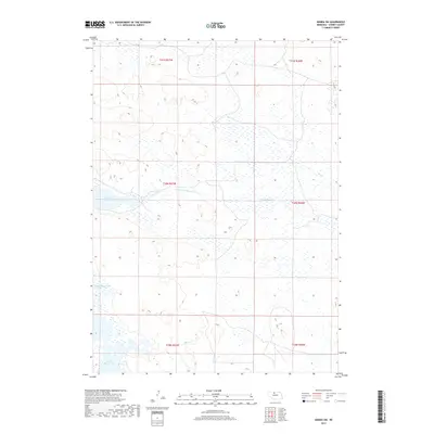
2017 Map of Arabia SW
USGS Topo · Published 2017About this map
Red Deer Lake and a series of expansive wetlands define this corner of the Nebraska Sandhills. This 2017 survey shows an intricate water network where the North Fork Plum Creek and its tributary N-Fork-Plum Cr wind through a landscape characterized by large, unnamed basins and seasonal marshes. The distribution of North Marsh Lake and South Marsh Lake illustrates the delicate hydrology of Cherry County, where low-lying drainage areas like Dry Cr connect a system of shallow lakes and intermittent ponds. The map is primarily structured by the Public Land Survey System, including portions of t30n r27w and t31n r27w, which delineate the sparse cattle ranching country typical of this region.
Find a feature on this map
12 named features on this map. Tap any name to fly to it.
Don’t see what you’re looking for? This feature index may not catch every label — zoom into the map to look around manually.
Map Details
Editions of this 2017 Arabia SW Map
This is the sole edition of this map. No revisions or reprints were ever made.
Other maps of this area

1949 · Long Lake
USGS Topo · 1:62,500

1950 · Simeon
USGS Topo · 1:62,500

1950 · Arabia
USGS Topo · 1:62,500

1951 · Long Lake
USGS Topo · 1:62,500

1951 · Brownlee
USGS Topo · 1:62,500

1957 · Valentine
USGS Topo · 1:250,000

1959 · Valentine
USGS Topo · 1:250,000

1985 · Long Lake
USGS Topo · 1:24,000

1985 · Wilson Valley
USGS Topo · 1:24,000
1985 · Arabia SE
USGS Topo · 1:24,000