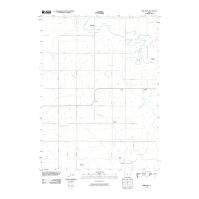
2010 Map of Arbor Hill
USGS Topo · Published 2010About this map
Arbor Hill and the surrounding agricultural landscape of Adair County are defined by the meandering courses of the Middle River and Thompson River. This survey captures a rural network of farmsteads and small settlements like Hebron and Stanzel connected by a rigid grid of local roads. The map is particularly useful for genealogical research, documenting several distinct burial grounds including Roberts Cemetery, Grand River Center Cemetery, Hebron Cemetery, and the Boley Farm Cemetery. While primarily agricultural, the landscape includes unique landmarks such as the Millers Country Zoo. The interplay between the natural hydrology of Bush Branch, Marvel Creek, and Battle Creek against the rectilinear sections of Trenton Ave and Stuart Rd illustrates the persistent structure of Iowa's township-and-range settlement pattern into the modern era.
Find a feature on this map
36 named features on this map. Tap any name to fly to it.
Don’t see what you’re looking for? This feature index may not catch every label — zoom into the map to look around manually.
Map Details
Editions of this 2010 Arbor Hill Map
This is the sole edition of this map. No revisions or reprints were ever made.
Other maps of this area

1951 · Afton
USGS Topo · 1:62,500

1952 · Winterset
USGS Topo · 1:62,500

1954 · Greenfield
USGS Topo · 1:62,500

1954 · Omaha
USGS Topo · 1:250,000

1957 · Omaha
USGS Topo · 1:250,000

1958 · Omaha
USGS Topo · 1:250,000

1981 · Zion
USGS Topo · 1:24,000
1981 · Orient
USGS Topo · 1:24,000
1983 · Rosserdale
USGS Topo · 1:24,000
1983 · Earlham West
USGS Topo · 1:24,000