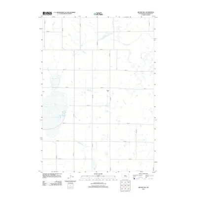
2012 Map of Archer Hill
USGS Topo · Published 2012About this map
White Lake and the surrounding prairie of Aurora County dominate this early 21st-century landscape, where a precise grid of rural roads like 375th Ave and 246th St defines the agricultural layout. The topographic relief is punctuated by the eponymous Archer Hill, a distinct elevation rising above the many small wetlands and depressions characteristic of this region. Water management is evident throughout the quadrangle, from the northern W Br Firesteel Cr to the southeastern Scott Lake and the drainage patterns of Wilkie Slough. A small Dam on the western edge of White Lake highlights local water control efforts in a territory where seasonal water levels significantly influence the terrain and land use.
Find a feature on this map
22 named features on this map. Tap any name to fly to it.
Don’t see what you’re looking for? This feature index may not catch every label — zoom into the map to look around manually.
Map Details
Editions of this 2012 Archer Hill Map
This is the sole edition of this map. No revisions or reprints were ever made.
Other maps of this area

1941 · Kimball North
USGS Topo · 1:62,500

1942 · Crow Lake
USGS Topo · 1:62,500

1951 · Kimball North
USGS Topo · 1:62,500

1955 · Mitchell
USGS Topo · 1:250,000

1959 · Mitchell
USGS Topo · 1:250,000

1979 · Crystal Lake
USGS Topo · 1:24,000

1979 · White Lake
USGS Topo · 1:24,000

1979 · Platte Lake
USGS Topo · 1:24,000
1982 · Wilmarth Lake
USGS Topo · 1:25,000
1982 · Kimball North
USGS Topo · 1:25,000
Featured Places
- Patten Township, SD
- White Lake Township, SD
- Pleasant Valley Township, SD
- Eureka Township, SD
- Lake Township, SD