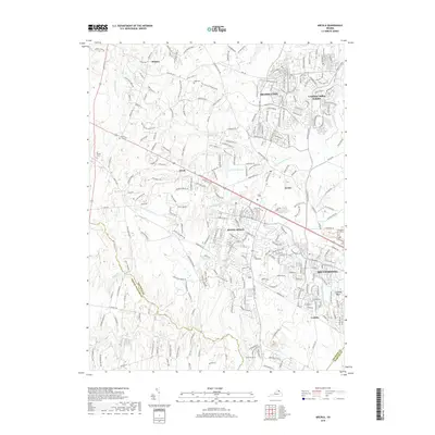
2019 Map of Arcola
USGS Topo · Published 2019About this map
South Riding and Stone Ridge anchor this detailed study of eastern Loudoun County's rapid suburban transformation in the late 2010s. The map illustrates a landscape of dense residential developments, such as Brambleton and Loudoun Valley Estates, intricately woven between historic watercourses like Broad Run and S Fork Broad Run. Evidence of the area's agricultural past remains visible through preserved family sites, including the Ish Family Cem and Mount Zion Cem, which stand as quiet landmarks amid modern thoroughfares. To the south, the terrain descends into the Culpeper Basin near Conklin, where Bull Run defines the boundary between Loudoun and Prince William counties. The road network reflects recent growth, with the Loudoun County Parkway and Dulles West Boulevard serving as primary arteries through these evolving communities.
Find a feature on this map
49 named features on this map. Tap any name to fly to it.
Don’t see what you’re looking for? This feature index may not catch every label — zoom into the map to look around manually.
Map Details
Editions of this 2019 Arcola Map
This is the sole edition of this map. No revisions or reprints were ever made.
Other maps of this area

1884 · Harpers Ferry
USGS Topo · 1:125,000

1890 · Mt. Vernon
USGS Topo · 1:125,000

1891 · Harpers Ferry
USGS Topo · 1:125,000

1891 · Mt. Vernon
USGS Topo · 1:125,000

1893 · Frederick
USGS Topo · 1:125,000

1893 · Harpers Ferry
USGS Topo · 1:125,000

1894 · Warrenton
USGS Topo · 1:125,000

1894 · Frederick
USGS Topo · 1:125,000

1894 · Mt. Vernon
USGS Topo · 1:125,000

1897 · Mt. Vernon
USGS Topo · 1:125,000