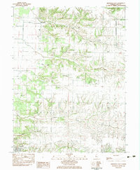
1983 Map of Arenzville East
USGS Topo · Published 1983About this map
Bluff Springs stands at the northern edge of this 1980s landscape, where the flatlands of the Sangamon Valley meet the dissected uplands of southern Cass County. The map is exceptionally dense with small family and community burial grounds, illustrating a deeply rooted rural genealogy. From the Jockisch Cem and Treadway-Miller Cem in the central hills to the Green-Krohe Cem further west, these landmarks indicate early settlement patterns along the bluffs. Drainage systems like Clear Creek and Prairie Creek carve through the terrain, leading down toward the village of Arenzville in the southwest corner. The presence of the Virginia Country Club and the small settlement of Jules in the east suggests a transition toward the county seat, while church sites like Bethel Ch and United Ch mark the social centers of this agricultural region during the late twentieth century.
Find a feature on this map
36 named features on this map. Tap any name to fly to it.
Don’t see what you’re looking for? This feature index may not catch every label — zoom into the map to look around manually.
Map Details
Editions of this 1983 Arenzville East Map
This is the sole edition of this map. No revisions or reprints were ever made.
Other maps of this area

1926 · Beardstown
USGS Topo · 1:62,500

1929 · Arenzville
USGS Topo · 1:62,500

1930 · Chandlerville
USGS Topo · 1:62,500

1932 · Arenzville
USGS Topo · 1:62,500

1932 · Chandlerville
USGS Topo · 1:62,500

1932 · Virginia
USGS Topo · 1:62,500

1936 · Virginia
USGS Topo · 1:62,500

1944 · Beardstown
USGS Topo · 1:62,500

1948 · Quincy
USGS Topo · 1:250,000

1956 · Quincy
USGS Topo · 1:250,000