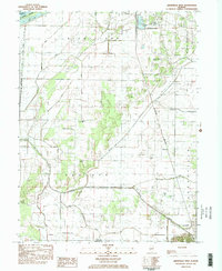
1983 Map of Arenzville West
USGS Topo · Published 1983About this map
The Illinois River corridor and its surrounding bottomlands define the geography of this 1983 survey, showcasing the vital water and rail infrastructure of Cass County. The busy river port of Beardstown anchors the northern boundary, where sewage disposal plants and industrial sites sit near the Burlington Northern line. The rail network cuts a straight path south through the prairie, passing through the small settlement of Hagener before reaching Arenzville at the edge of the southern bluffs.
Find a feature on this map
26 named features on this map. Tap any name to fly to it.
Don’t see what you’re looking for? This feature index may not catch every label — zoom into the map to look around manually.
Map Details
Editions of this 1983 Arenzville West Map
2 editions found
Other maps of this area

1923 · Rushville
USGS Topo · 1:62,500

1926 · Beardstown
USGS Topo · 1:62,500

1926 · Rushville
USGS Topo · 1:62,500

1928 · Meredosia
USGS Topo · 1:62,500

1929 · Arenzville
USGS Topo · 1:62,500

1931 · Meredosia
USGS Topo · 1:62,500

1932 · Arenzville
USGS Topo · 1:62,500

1944 · Beardstown
USGS Topo · 1:62,500

1948 · Quincy
USGS Topo · 1:250,000

1956 · Quincy
USGS Topo · 1:250,000