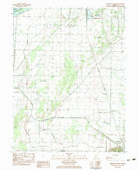
1983 Map of Arenzville West
USGS Topo · Published 1983About this map
Illinois River lowlands and the eastern bluffs dominate this landscape in Cass County, where the transition from river bottom to high ground is marked by Bluff Springs. The map illustrates the agricultural and transport network of the early 1980s, anchored by the Burlington Northern railroad corridor. Smaller communities and rural hubs like Hagener and Arenzville are connected by a web of drainage ditches and creeks, including Indian Creek and Clear Creek. Local history is preserved through the locations of several country burial grounds and houses of worship, such as Schneider Cem, Wagle Cem, and Black Oak Ch. In the north, the industrial and aviation infrastructure of Beardstown is evident, featuring the Greater Beardstown Airport and extensive sewage disposal facilities near the riverbank.
Find a feature on this map
28 named features on this map. Tap any name to fly to it.
Don’t see what you’re looking for? This feature index may not catch every label — zoom into the map to look around manually.
Map Details
Editions of this 1983 Arenzville West Map
2 editions found
Other maps of this area

1923 · Rushville
USGS Topo · 1:62,500

1926 · Beardstown
USGS Topo · 1:62,500

1926 · Rushville
USGS Topo · 1:62,500

1928 · Meredosia
USGS Topo · 1:62,500

1929 · Arenzville
USGS Topo · 1:62,500

1931 · Meredosia
USGS Topo · 1:62,500

1932 · Arenzville
USGS Topo · 1:62,500

1944 · Beardstown
USGS Topo · 1:62,500

1948 · Quincy
USGS Topo · 1:250,000

1956 · Quincy
USGS Topo · 1:250,000