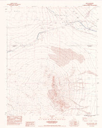
1983 Map of Arica Mountains
USGS Topo · Published 1983About this map
The Arica Mountains dominate this high desert landscape, marking the boundary where the peaks meet the wide expanse of Ward Valley. This 1983 edition highlights the critical infrastructure required to move water through the arid interior, specifically the Colorado River Aqueduct (Underground) and its associated ditches. The rugged terrain is punctuated by small-scale industrial history, such as a Prospect mine, and the remnants of early desert life found at Priests Well (Dry). Transport and connectivity are defined by the Atchison Topeka and Santa Fe railroad line and State Highway 62, both of which cut through the northern reaches of the quadrangle. Significant areas of Sand Dunes are also noted, illustrating the shifting, undeveloped nature of the land between the mountain ranges and the county line.
Find a feature on this map
12 named features on this map. Tap any name to fly to it.
Don’t see what you’re looking for? This feature index may not catch every label — zoom into the map to look around manually.
Map Details
Editions of this 1983 Arica Mountains Map
This is the sole edition of this map. No revisions or reprints were ever made.
Other maps of this area

1942 · Blythe
USGS Topo · 1:250,000

1942 · Amboy
USGS Topo · 1:250,000

1943 · Amboy
USGS Topo · 1:250,000

1943 · Iron Mountains
USGS Topo · 1:62,500

1945 · Midland
USGS Topo · 1:62,500

1952 · Midland
USGS Topo · 1:62,500

1952 · Palen Mountains
USGS Topo · 1:62,500

1954 · Salton Sea
USGS Topo · 1:250,000

1954 · Needles
USGS Topo · 1:250,000

1954 · Rice
USGS Topo · 1:62,500