
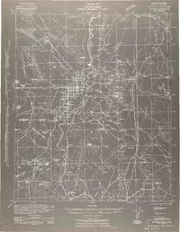
1942 Map of Blythe
USGS Topo · Published 1942About this map
The Colorado River serves as the central artery for this 1942 desert landscape, defining the boundary between California and Arizona during the Second World War. On the California side, the agricultural grid of the Palo Verde Mesa is well-established, anchored by Blythe and the southern terminus of the Atchison Topeka & Santa Fe at Ripley. Across the river, the Arizona landscape is dominated by mining operations and the sprawling Colorado River Indian Reservation.
Find a feature on this map
129 named features on this map. Tap any name to fly to it.
Don’t see what you’re looking for? This feature index may not catch every label — zoom into the map to look around manually.
Map Details
Editions of this 1942 Blythe Map
2 editions found
Other maps of this area

1903 · Yuma
USGS Topo · 1:125,000

1905 · Yuma
USGS Topo · 1:125,000

1907 · Holtville
USGS Topo · 1:125,000

1911 · Parker
USGS Topo · 1:125,000

1923 · Signal
USGS Topo · 1:250,000

1928 · Norton
USGS Topo · 1:62,500
1929 · Laguna
USGS Topo · 1:62,500

1929 · Norton
USGS Topo · 1:62,500

1930 · Linskey
USGS Topo · 1:62,500

1931 · Moon Mtn
USGS Topo · 1:62,500