
1931 Map of Moon Mtn
USGS Topo · Published 1955About this map
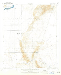
The Colorado River serves as the primary boundary and lifeline in this early twentieth-century survey of the Arizona-California border. The landscape is dominated by the Dome Rock Mountains and the prominent Moon Mtn, which rise sharply above the La Posa Plain. Much of the western territory is designated as the Colorado River Indian Reservation, reflecting the administrative and social geography of the era. Evidence of mineral prospecting is visible in the southeastern reaches of the mountains, specifically at the Valenzuella Mine and Mammoth Mine. Drainage patterns like the Tyson Wash illustrate the seasonal hydrology of this arid region, providing a detailed look at the intersection of natural topography and mining history before mid-century developments.
Find a feature on this map
9 named features on this map. Tap any name to fly to it.
Don’t see what you’re looking for? This feature index may not catch every label — zoom into the map to look around manually.
Map Details
Editions of this 1931 Moon Mtn Map
2 editions found
Other maps of this area

1911 · Parker
USGS Topo · 1:125,000

1930 · Linskey
USGS Topo · 1:62,500

1932 · Moon Mtn
USGS Topo · 1:62,500

1933 · Cunningham Mtn
USGS Topo · 1:48,000

1940 · Dome Rock Mts
USGS Topo · 1:62,500

1942 · Blythe
USGS Topo · 1:250,000

1942 · MOON MTN
USGS Topo · 1:62,500

1943 · Parker
USGS Topo · 1:62,500
1943 · Vidal
USGS Topo · 1:62,500

1945 · Big Maria Mtns
USGS Topo · 1:62,500