
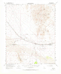
1954 Map of Rice
USGS Topo · Published 1955About this map
The desert landscape of the California interior is defined here by the industrial and military infrastructure that sustains transit through its arid basins. Rice serves as a central hub, situated at the junction of the Atchison Topeka and Santa Fe railroad and the Colorado River Aqueduct. South of the settlement, the vast Rice Air Base and its airfield dominate Rice Valley, reflecting the strategic importance of the region during the mid-century. The terrain transitions from the high peaks of the Turtle Mountains, where Horn Peak rises above the Virginia May Mine, down to the shifting sands of Vidal Valley. Small outposts like Sablon and Freda trace the rail line, while isolated water sources such as Horn Spring and Priests Well mark the traditional waypoints across the Sand dunes and alluvial fans of the Arica Mountains.
Find a feature on this map
24 named features on this map. Tap any name to fly to it.
Don’t see what you’re looking for? This feature index may not catch every label — zoom into the map to look around manually.
Map Details
Editions of this 1954 Rice Map
2 editions found
Other maps of this area

1942 · Blythe
USGS Topo · 1:250,000

1942 · Amboy
USGS Topo · 1:250,000

1943 · Amboy
USGS Topo · 1:250,000

1943 · Turtle Mts.
USGS Topo · 1:62,500

1943 · Vidal
USGS Topo · 1:62,500

1943 · Iron Mountains
USGS Topo · 1:62,500

1945 · Big Maria Mtns
USGS Topo · 1:62,500

1945 · Midland
USGS Topo · 1:62,500

1949 · Vidal
USGS Topo · 1:62,500

1950 · Vidal
USGS Topo · 1:62,500