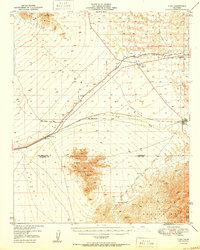
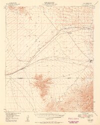
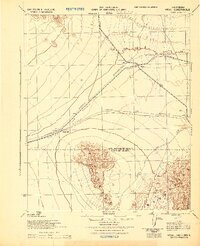
1950 Map of Vidal
USGS Topo · Published 1950About this map
The Colorado River Aqueduct carves through the arid landscape of the Mojave Desert, serving as a critical piece of mid-century water infrastructure. This survey captures a remote region defined by the intersection of industrial ambition and harsh terrain, where the Atchison Topeka and Santa Fe railroad follows the San Bernardino Base Line toward the river valley. Sparse settlements like Vidal and the Vidal Junction (Plant Quarantine Station) highlight the area's role as a transit and monitoring point for travelers entering California.
Find a feature on this map
22 named features on this map. Tap any name to fly to it.
Don’t see what you’re looking for? This feature index may not catch every label — zoom into the map to look around manually.
Map Details
Editions of this 1950 Vidal Map
2 editions found
Other maps of this area

1911 · Parker
USGS Topo · 1:125,000

1931 · Moon Mtn
USGS Topo · 1:62,500

1932 · Moon Mtn
USGS Topo · 1:62,500

1942 · Blythe
USGS Topo · 1:250,000

1942 · MOON MTN
USGS Topo · 1:62,500

1943 · Whipple Mts.
USGS Topo · 1:62,500

1943 · Parker
USGS Topo · 1:62,500
1943 · Turtle Mts.
USGS Topo · 1:62,500
1943 · Vidal
USGS Topo · 1:62,500

1945 · Big Maria Mtns
USGS Topo · 1:62,500