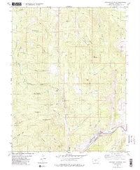
1980 Map of Arkansas Mountain
USGS Topo · Published 1985About this map
The Arkansas River corridor serves as the primary artery for transport and activity in this high-altitude landscape. Along its banks, the Denver and Rio Grande Western railroad tracks follow the river's path, passing the small settlement of Cotopaxi and the Pasture Roadside Park. This 1980s-era documentation shows an economy shaped by mineral extraction and recreation, with a Mine Quarry located in the southern hills and various Gravel Pits near the river canyon. The surrounding terrain is defined by prominent peaks like Park Mountain, Garell Peak, and Arkansas Mountain. An intricate network of drainages, such as Red Gulch, Indian Spring Gulch, and Falls Gulch, dissects the uplands, highlighting the complex water table that sustains features like Bernard Spring and Mud Spring in an otherwise arid environment.
Find a feature on this map
45 named features on this map. Tap any name to fly to it.
Don’t see what you’re looking for? This feature index may not catch every label — zoom into the map to look around manually.
Map Details
Editions of this 1980 Arkansas Mountain Map
3 editions found
Other maps of this area

1954 · Pueblo
USGS Topo · 1:250,000

1956 · Cameron Mountain
USGS Topo · 1:62,500

1957 · Pueblo
USGS Topo · 1:250,000

1958 · Pueblo
USGS Topo · 1:250,000

1959 · Black Mountain
USGS Topo · 1:62,500

1959 · Howard
USGS Topo · 1:62,500

1959 · Cotopaxi
USGS Topo · 1:62,500

1962 · Pueblo
USGS Topo · 1:250,000

1966 · Pueblo
USGS Topo · 1:250,000
1980 · Echo
USGS Topo · 1:24,000